Causes of Earthquake
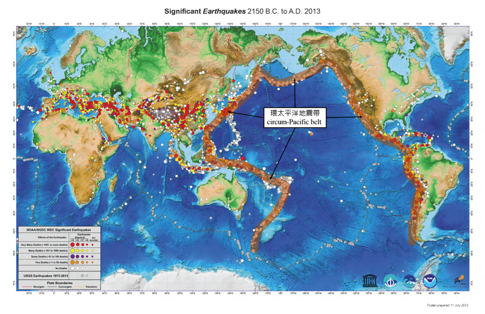
Earthquakes can be divided into naturally occurring earthquakes and man-made earthquakes. Naturally occurring earthquakes are mainly caused by tectonic movement or volcanic eruption while man-made earthquakes are generated by human activities. Most of the strong earthquakes in the world occurred at tectonic plate boundaries. The famous circum-Pacific belt (also called the "Ring of Fire") is located at the boundary of the Eurasian and Pacific plates, passing through Japan, Taiwan and the Philippines.
(Source: International Tsunami Information Centre)
Seismic Waves and Earthquake Detection
Basic earthquake parameters for monitoring include: origin time, epicentre, focal depth and magnitude.
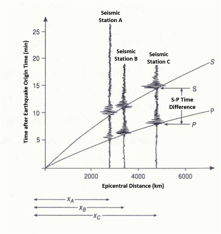
After an earthquake occurs, the energy released will propagate outwards in all directions in the form of seismic waves. Generally speaking, the amplitude of seismic waves recorded by a seismograph is higher for a larger earthquake. As seismic waves attenuate while spreading out, the seismic wave recorded at places farther from the epicentre is smaller. One can compute the earthquake magnitude based on the amplitude of the seismic waves recorded by a seismograph, after accounting for the distance between the earthquake epicentre and the seismograph station (epicentral distance).
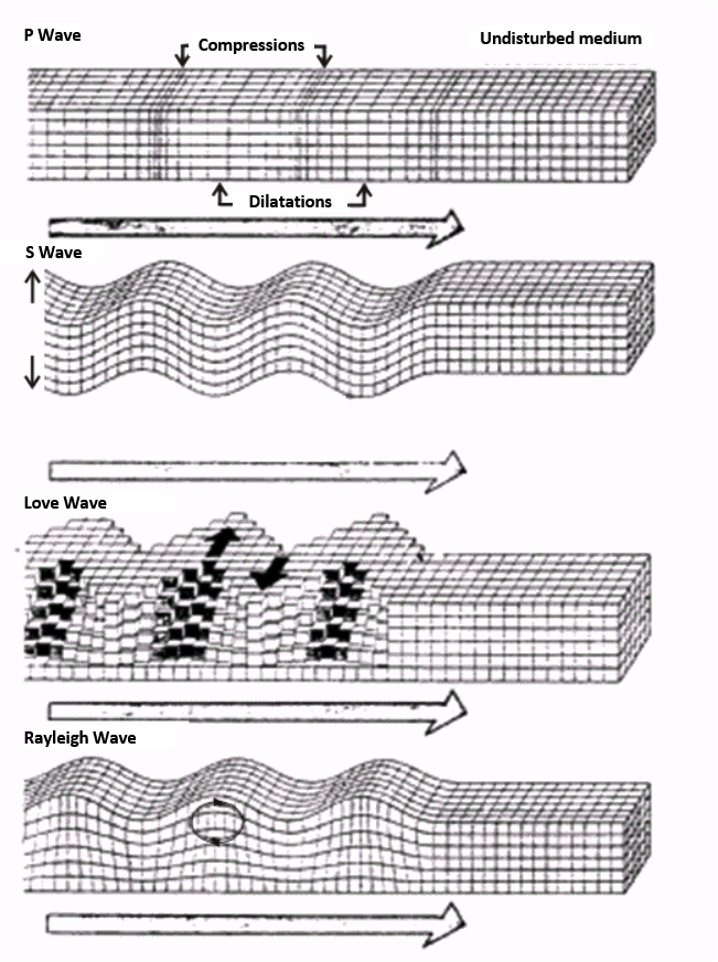
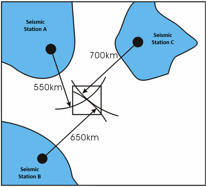
Seismic waves are classified into two broad categories. One propagates within the body of the Earth, thus known as "body waves", which can be further divided into longitudinal wave (P wave) and transverse wave (S wave). The other propagates along the surface of the Earth, thus known as "surface waves", can be further divided into Love Wave and Rayleigh Wave according to the propagation mode. The speeds of propagation of different seismic waves are different. P waves travel the fastest (5-7 km/s), followed by S waves (3-4 km/s) and surface waves (2-3 km/s). Nevertheless, surface waves are the largest and thus inflicted the greatest damages, followed by S waves, whereas P waves are the smallest. According to the time difference between the arrival times of P and S waves, the origin time and the epicentral distance can be computed. Taking into account the arrival times of P and S waves of seismic stations at different locations, the epicentre position can be calculated using triangulation method.
Magnitude and Intensity
The earthquake magnitude quantifies the size or scale of an earthquake, which is generally related to the energy released. The concept was first proposed by Mr Charles Richter in 1935. After decades of development, there are now dozens of methods to compute earthquake magnitudes. Four of them are most commonly used, which are local magnitude Ml, body wave magnitude mB, surface wave magnitude Ms and moment magnitude Mw.
The local magnitude Ml is applicable to an earthquake near a seismograph station, and is commonly known as the "Richter Scale" (http://www.hko.gov.hk/gts/equake/richter_e.htm). The body wave magnitude mB, surface wave magnitude Ms and moment magnitude Mw, commonly adopted by most earthquake and tsunami monitoring centres nowadays for distant earthquakes.
The intensity of an earthquake at a particular locality indicates the violence of earth motion produced there by the earthquake. It is determined from reported effects of the tremor on human beings, furniture, buildings, geological structure, etc. Many places, including Hong Kong, have adopted the Modified Mercalli Scale (MMS) which classifies earthquake effects into twelve grades (http://www.hko.gov.hk/gts/equake/mms_e.htm).
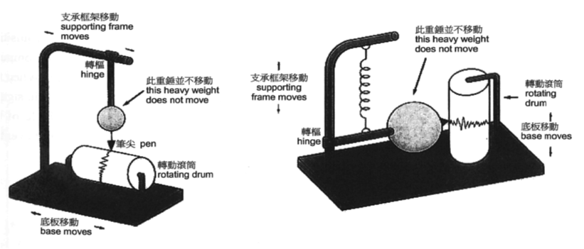
Principle of Earthquake Detector
Earthquake detectors operate on the principle of inertia of stationary objects. Using the following diagrams as example, the hanging heavy weight of the earthquake detection device remains stationary unless a force is applied to it. The heavy weight tends to remain stationary following sudden movement caused by the passage of seismic waves, while the frame and drum in contact with the ground move with the ground. Recording the relative motion between the heavy weight and the base or supporting frame could record the seismic waves.
Earthquake Monitoring at Hong Kong Observatory
The Hong Kong Observatory (HKO) has monitored distant earthquakes since 1921 using long-period seismographs. In 1979, a short-period seismograph network was established for monitoring local tremors. Development of the seismograph network continues with the advancement in science and technology. Nowadays, HKO has installed broadband seismographs at Po Shan Road, Mid-levels and the HKO's Headquarters, Tsim Sha Tsui to monitor earthquakes worldwide, especially those earthquakes in the South China Sea that will probably generate tsunami. The Po Shan Seismograph Station is one of the about 150 members of the Global Seismographic Network that possess broadband seismograph, its recorded seismic waves are provided to various tsunami centres around the world via the Incorporated Research Institutions for seismology (IRIS) in the United States.
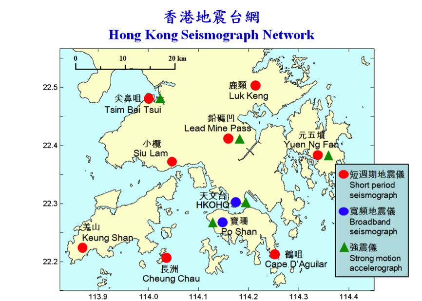
HKO also operates eight short period seismograph stations at Cape D'Aguilar, Cheung Chau, Keung Shan, Lead Mine Pass, Luk Keng, Siu Lam, Tsim Bei Tsui and Yuen Ng Fan respectively. This coupled with the seismograph stations at Po Shan and the HKO's Headquarters form a local earthquake monitoring network of ten stations for determining effectively the epicentre of locally felt earthquakes in Hong Kong's nearby regions. Accelerographs are also installed at some seismograph stations for recording peak ground acceleration during felt earthquake which help to determine the earthquake intensity in Hong Kong.
HKO's earthquake data processing system collects real time seismic waveform data from global and Hong Kong seismograph networks to compute earthquake parameters such as origin time, epicentre and magnitude. HKO also collects earthquake and tsunami information issued by the State Oceanic Administration, China Earthquake Administration, Earthquake Administration of Guangdong Province, Pacific Tsunami Warning Center (PTWC), Northwest Pacific Tsunami Advisory Center (NWPTAC), West Coast and Alaska Tsunami Warning Center (WCATWC) and U.S. Geological Survey.
For locally felt earthquake and larger earthquake worldwide, HKO will issue quick earthquake messages via social websites and RSS to the public, and also SMS and emails to news agencies, media, related government policy bureaux and departments as well as earthquake and tsunami monitoring centres overseas. In addition, HKO will issue strong earthquake reports and locally felt earthquake reports to the media via the Information Services Department (ISD).
Reference links:
- Global Earthquake Information Webpage
- HKO Earthquake M6.0
- HKO Earthquake M5.0
- Earthquake Reports
- Hong Kong Observatory "Cool Met Stuff"-地「洞」山「窰」
- Hong Kong Observatory "Cool Met Stuff"-地震烈度
- Hong Kong Observatory Educational Resources
- International Association of Seismology and Physics of the Earth’s Interior (IASPEI)
- Incorporated Research Institutions for Seismology (IRIS)
- China Earthquake Administration (CEA)
- U.S. Geological Survey (USGS)